A Lazy Morning
5am came fast, and we were

woken by the sound of footsteps trudging on the pebble beach. We watched from the safety of our cozy sleeping bags as many groups started to eat breakfast and break camp to get an early start on the trail ahead. The group of four that were ahead of us were shooting to be done in 4 days – and so were off to an early start. We didn't pass anyone else on the Day 1 and were first to get on the trail and last to arrive at Camper – we figured that all of the other groups must be heading South to Gordon river. Getting an early start to ensure they make the ferry crossing before dark.
We chose the lazy morning option – this was a vacation after all. We were the last to arrive at camp and close to the last to leave. Were we setting a trend for the remainder of the trip? Certainly we lived up the the last to arrive part, as you will discover…
We were on the trail for about 9am – after a hearty breakfast of Alpen and instant italian espresso. We wanted to prepare our bellies for what was reputed as the most difficult stretch of trail – the "ladder day from hell". I should note that after many experiments to find a good option for making fresh coffee, I settled on the instant espresso stuff for three reasons 1. it was lighter, 2. it was easier to prepare and dispose of and 3. it tasted quite decent.

Today we knew we were in for a grueling day. The guide books say that the section between camper and Logan is one of the toughest – with large ladder sections going into and out of Culite. Our goal today was to at least clear Walbran – the divider between the hard/easier parts of the West Coast Trail. It is a modest 10k to Walbran, so we were confident we could accomplish at least that. However, the tides were against us leaving Camper and so our initial intention of taking the shelf and then scramble up Sandstone Creek was abandoned in favour of the forest path. So back into the mud pits we go!
Turtle Crossings
After the first day we had naturally established a pace that seemed to work for everyone. Day 2 – not unlike Day 1, or for that matter the days to come

– required caution with every step. If it wasn't mud it was slippery moss covered tree crossings. Bill & I quickly learned this as we were awarded the first (and only) spectacular "Double Turtle" prize of the trip. The West Coast Trail "Turtle" is the name fondly assigned by the ranger lady for the situation where one slips off a boardwalk or log crossing and ends up on your back with legs and arms flailing around in the air. On a large log crossing, I was about to step off the log when suddenly my feet disappeared from under me. I fell off to the left a few feet down into some bracken, yelling as I went. Seconds later, I swore I could still hear the echo of my yell from among the trees. Oh – wait – never mind. That's Bill's voice not mine. Apparently as soon as I yelled out mid-fall Bill looked up to watch me tumble only to himself lose traction and follow me down into the forest. Tim & Theresa were both behind us and somewhat confused at where we had both gone to. Space alien abduction on the West Coast Trail? We both crawled back out from under the log and all was made clear. The injuries were scant – possibly the worse injury was to Tim's diaphragm from laughing so hard.

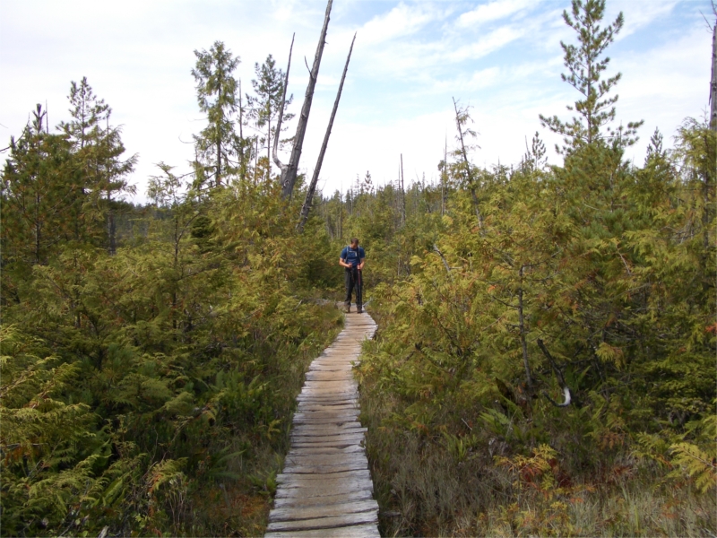
Thank goodness for our poles as they were invaluable in navigating the endless mud and tree roots that obstructed the majority of the trail. With every step there was a fateful decision to make-which route to make it past the mud (two feet deep in places)- through the brush to the left? forge a new path to the right? or tip-toe carefully down the middle like frogger over stumps and roots hoping that each step is solid enough not to sink too deep before progressing to the next foot hold.
Storm Damage
The trail between Camper and Sandstone was tough

going. It climbed up out of Camper and was a mixture of thick mud with occasional runs of boardwalks. About a half hour out of Camper we started to come across some sections of forest that had been very badly damaged in the 2006 winter storm. The sheer number of trees fallen was staggering. Parks Canada estimated that over 2000 trees came down across the trail. When you think of all that ones that fell and didn't land across the trail – that's a shocking number. Living in Seattle, we felt the force of some of that wind storm also – I remember sleeping downstairs in our house that night for fear of our large tree crashing down in our bedroom – I shudder to think what it must have been like in this forest at that time.

The photos here really don't do the scope of the situation justice. A single fallen old-grown would start a chain reaction that would knock out almost an entire football field of other trees. Huge root balls were torn up out of the ground around us. Later on the trail we ran into one of the maintenance workers who worked hard at clearing this trail in the spring. I thanked him profusely and was in awe of all the effort and hardwork the crews put in to get the West Coast Trail in such incredible shape for the hiking season.
Sandstone Creek
After a few hours we came upon Sandstone creek.

It was a very pretty river with lots of tannins that made it deep brown. The water was shallow flowing over a thick bed of sandstone. After crossing the bridge on the other side we could see a rope where the 'scramble' up the embankment was. Maybe we'll get to do the shelf and the scramble some other time. We didn't linger too long here and kept forging on towards Culite.
Snakes & Ladders
Ok… I'm over exaggerating. We didn't see any snakes – but certainly saw a lot of ladders.

The section between Sandstone and the Culite ladders went fast and before we knew it we were upon them around 12:30pm. We could see all the way down to Culite creek from above the ladders and see the cable car over the creek. It looked like and long way down, and there certainly were a bunch of ladders to prove it. However, the ladders went fast and easy with our poles stowed on our packs.
One ladder in particular was very long and it made one wonder how many of the West Coast Trail "evacuations" each year were due to a ladder fall. Each ladder section started off being quite muddy for the first five or six rungs (from peoples boots) and then cleaner until the last set of rungs. The rungs are basically 2×4 sections of cedar – most of which have bit divots where heavy boots have worn into them over the years. The parks service asks that hikers keep a good distance between themselves while on ladders – people should only enter a ladder as another person is within a few rungs of exiting. I suppose they are trying to reduce the possibility of a domino effect.

As this is an ultralight blog, I suppose now is a good time to geek out with a few gear notes. I wore my relatively new Golite Sundragon shoes for this trip. They performed well on most of the terrain, but I was less thrilled with them on the ladders. If you look at the picture of the soles of the Sundragon, you'll see that there is a decent size gap between the last of the 'lugs' and the heel. I found my footing to gravitate occasionally to using this area on the rungs of the ladders. The area was a little softer than other areas of the shoe and over time I felt like my foot would begin to bruise in this spot. I didn't get too bruised, but I found myself trying to avoid using this area of the shoe. Another downside is that you can't easily hold an umbrella while going down the ladders. There were some that worked OK if the umbrella was secured into the chest-strap of our packs – but on the most part we downed our umbrellas and got a little wet while descending.
Cable Cars Technique
At the base of the ladders there is a fun cable car crossing to get across Culite before ascending a long (but shorter) set of ladders on the other side. This is where Theresa and I perfected our cable car crossing technique. The trick is to send Bill & Tim across first. Have them haul the cable car back over to our side. Hop in, let gravity take us to the center of river and then start pulling. Now for the tricky part… you can't pull too aggressively – you need to pull for a little bit, pause, feign a little 'tiredness' and then pull again. After about a minute or two of this Tim & Bill take pity of us and then begin pulling on the other end. To make Tim & Bill feel good about themselves that they aren't doing all of the work you then have to employ the 'cable slap' maneuver. This involves faking putting your hands on the cable and looking like you are pulling, yet really not touching the cable at all. Once you get close enough to the other side, where they might be able to detect the slapping technique you have to start pulling again – but not too hard – otherwise they notice the difference.
And so went all of the cable car crossings from here on out.

After crossing the river we started to climb the ladders on the other side. At the foot of the first ladder we passed another group coming down. They told us to hold up as "a dad and daughter combination are on their way down". We were not quite prepared for what we saw next… coming down the ladder came a dad, followed by a six maybe eight year old little girl. She was carrying a pack that I swear was bigger than ours. I was blown away that she could hike the West Coast Trail, gob-smacked that she just descended a huge set of ladders and in awe that she was about to climb up what we just came down on the other side. She didn't say much as she went by – just muttered "yum yum um um um" and put her hands to her mouth – like she was very hungry and was ready for a break.
After another fifteen minutes or so of climbing we reached the top of the ladders. On to Logan we go!
The Ancient Bog
The section between Culite and Logan was quite extraordinary.

For one it was several miles almost entirely on boardwalk and secondly it was through an ancient and mystical bog. It was quite unlike the rest of the trail.
The trees here were stunted and low. Apparently caused by a lack of nitrogen in the soils. Due to this the area didn't have any logging value and so was never logged, so it's in pristine condition. It was a very swampy area and presumably stayed damp most of the year. The boardwalk protects the vegetation from all the foot traffic but allowed us to get in and see this special place. The sun
came out for us while we were in their and it was quite breathtaking.
While on the boardwalk we ran across 3 guys from Texas (sounds like an old western movie). They were heading South and had stopped on the boardwalk for lunch. They had their stoves out and were munching on something hot – it looked like mac & cheese. It was 1pm and I started getting hungry for lunch. Time to press on to Logan for lunch at the bridge.
Lunch at Logan
Within the hour we arrived upon Logan, dropping down a few ladders until the suspension bridge. We didn't cross the bridge a first, but

descended down the ladders next to it into Logan camp on the beach. Here we were able to fill up our water bottles and take a leisurely lunch. Tim cracked open his most prized possession of the trip – Beechers Handmade Cheese from Pike Place Market in Seattle – it was a hit. Meanwhile Theresa and I tucked into Cheshire cheese (from my home county in England), Salami and crackers. Followed by dark chocolate with espresso beans for desert. It was one of the best lunches on the trail. Fabulous!
We wandered out on the beach to watch for whales. Sadly we didn't see any, but we did see some wardens in a rescue boat off shore a little. Probably waiting for that first evacuation phone call of the day. With several hundred evacs a year, we figured that had to be close to two-a-day – hard to imagine.
Logan looked like a nice beach to camp at – but boy did the toilet there stink!

Around 2:30pm, after a long lunch, we climbed back up the ladders and onto the suspension bridge. The previous bridge was wiped out in the big wind storm last year. The suspension bridge is long and held up by huge tensioning anchors bolted into the rock. You can see in the picture where the old anchors were left in place and the new anchors added just above them. I assume the old anchors were stressed to the point it was too risky to re-use them.

![]()
Walbran Creek
We crossed the bridge, climbed the ladders and were back into the forest. We pushed on with yet more mud pits and tree roots, slogging another slow three kilometers on to Walbran Creek.


Walbran seemed like a pleasant camp site at first. It had the most incredible "Rolls Royce" toilet of the entire West Coast Trail. It was brand new, sort of 'open air' – yet sheltered and even came complete with reading material – readers digest AND car & driver magazines. I took my time here.
We rejoiced in the apparent knowledge that the "worst half" of the West Coast Trail was now over, and so far it really hadn't seemed as grueling as we were expecting. The rest of it would be a "walk in the park" by comparison, right? Not so much, as things turned out…
We considered camping at Walbran but it was still fairly early in the day – just after 4pm. Vancouver Point is impassable at high tides – which is precisely where the tide would be an hour from now. We decided to push on to Bonilla for the night, which gave us no option but to get back on the darn forest trail and forsake another beach option to get around Vancouver Point. By the time we traverse the beach after that we should be able to get around the other impassible headland at IR3.

After we turned away from the beach at Walbran to get to the cable car, we saw why people coming N->S did not recommend staying at Walbran. The river was stinky and polluted with Seagull feathers and poop. We considered filling up with water here as we were almost out, but couldn't bear the thought.
Walbran Creek was quite high and so we needed to take the cable car to get over it. It turned out to be a LONG cable car crossing too.
Brown Water
The forest trail was yet again another hard slog. "I thought we were done with the hardest part?" "So much for the walk in the park"

were some of the phrases uttered more than just once. After another klick or so, Theresa and I were getting thirsty as we were out of water. We came upon a trickle of a stream that offered a very dark brown water – heavy in tannins from the trees. It looked nasty, but was the only option. We popped in a few MicroPur tabs and had to wait a good hour before we could drink. This "skanky water" was our backup in case we got really thirsty before camp.
No Sand between our toes
Eventually we came upon the beach access. We were re-energized and excited – this was about to be our first beach hike of the West Coast Trail.

It was an excellent change of pace to be hiking on soft, flat sand rather than the hard , concentration-demanding tree roots. The sand was not without its challenges – hiking close to the surf-line proved to be the best technique as the recently soaked sand was more compact and faster going. Having gaiters were invaluable. I would mention with much ultralight geek proudness that they only added 1.5 oz to our pack weight, but they never came off my feet the entire trip (except for sleeping of course), and so even a heavier pair would have been fine. But these were more than enough for keeping the sand out and worth their weight in gold.

The beach hike was varied – sand some times and medium sized boulders and rocks other times. Hiking in a line and following the leaders foot steps was also a really good way of saving energy in the sand. The downside of this approach is that you are looking at your feet more to stay in the tracks rather than admiring the beauty of the surroundings. I alternated between the two for a good compromise.

![]()
We ended up reaching the point around IR3 at the perfect time – the tide was just receding from its high point and graciously offered us just enough room to navigate the beach around the point. At the most tide-critical point we saw a book lying on the rocks. It wasn't wet – and looked recent. We then noticed a single set of fresh human footprints going in our direction. It seemed odd, as not 15 minutes ago must the tide have been right here. We rounded the point but never did see the owner of the book or footsteps. Perhaps one of the locals living on the Indian reservation?
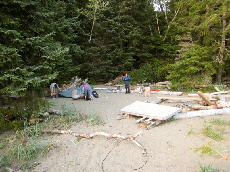
Bonilla Point
We arrived at Bonilla at around 6:50pm. Bonilla was our favourite camp – it was small and cozy with a waterfall tucked in behind it. Soon after we arrived and setup our tent, I went in search of drinking water. My plan was to fill from the waterfall for a delightfully fresh batch. As I waded into the plunge pool and soon realized it was too deep for me to reach the falls without getting very wet. The plunge pool was full of rocks covered with slimy green algae.
I went back to camp and declared to the group – "I have 2 bits of bad news and 1 bit of good news – which you you want first?" "The first bad news is that I couldn't reach the falls. The second is that our water is full of green algae and floaty bits.", "So what's the good news?", asked Tim. "Well… I still have a full 2 liters of skanky brown water from that stream earlier, which is sounding pretty good about now."

Bonilla was very quiet compared to the previous night at Camper. There was one other group when we arrived and one group came in after us. We cooked up a delicious meal, struggled to hang our two bags of food on a single rope, and headed out to the beach to watch the sun set on the beautiful sea stacks on the shore.
After the sunset Boy Scout Bill rubbed a few sticks together, added a little fire starting paste and got a spectacular roaring fire going.
A little while later and we retired to bed. Thankful that we had cleared the toughest part of the West Coast Trail and fearful of the rains that we knew were only hours away.
Brett, your writing style and addition of great photos are making for an excellent read of your hike. Keep it up!
– Sam
Did the Trail in June 0f 2012. This is hysterical. Wish I would have seen this before I went.