Category Archives: Wonderland Trail

Wonderland Trail Trip Report – Day 7

South Puyallup River -> Mowich Lake

Total Distance: 21.7 mi
Date: 9/5/2009

Indoor Swimming Pool

I woke up around 6:30 to the feel of wet feet. It rained hard in the night, and the area we pitched the Tarp Tent was not a good one. A huge puddle of standing water formed at the bottom of the tent and because I have a 1st generation Cloudburst without the bathtub floor – it overflowed the ground sheet and came a few feet into the tent. With a lightweight down sleeping bag, this would have been unfortunate. Luckily for us – we were planning on being off the trail tonight – so it didn't matter too much.

Continue reading

Wonderland Trail Trip Report – Day 6

Paradise River to South Puyallup River

Total Distance: 14.6 mi
Date: 9/4/2009

minimap-day6

A Stir in Camp

The morning started average enough. Wake up, go for a pee, get the stove going start to make breakfast etc etc. That is, until Dave decide that it would be a brilliant idea to accidentally knock his cup over, next to the wasp nest entrance – and watched it tumble into the opening.

Almost every wasp in the nest decided to come for a little visit to see what the commotion was. We backed away and kept a little distance. After five minutes or so, they decided that Daves cup wasn’t a big threat and slowly started flying back into the nest. Whew.

Continue reading

Wonderland Trail Trip Report – Day 5

Maple Creek -> Paradise River

Total Distance: 7.4 mi (10.6 mi Unofficial)

A Soggy Start

The rain slowed to a trickle in the early morning so we hopped up and took advantage of the lull to grab some breakfast. The toilets were so overflowing in Maple Creek that we decided not to contribute to the problem and broke out the trowel and set up camp  in the nearby clearing.

After packing away the soggy tent, we broke camp around 9:30.

The trail started out innocent enough – traversing Stevens Creek in the woods. Soon we came across badly conditioned sections of the trail – lots of washouts and erosion from flooding with make-shift paths around.

The overgrowth was wet and made for a soggy morning stroll. We powered on and soon put the easy miles to the lakes behind us. The trail crossed the road several times on the way to Reflection lakes – with the occasional car rolling by.

At Myrtle Falls a bridge was out and a big tree had been felled to create a temporary bridge.

Continue reading

Wonderland Trail Trip Report – Day 4

Indian Bar -> Maple Creek

Total Distance: 10.0 mi

A Nibble Free Night

We woke up at 6:30 to a full view of the other side of the river from the missing wall of the shelter. Phew – we made it through the night without getting pooped on or nibbled by mice.

I stepped outside to assess the situation. Given the low cloud and changing weather in the evening I thought we might be in for a rough day. Outside the shelter at first the skies seemed grey, but as my eyes adjusted to the light I realized that they were crystal clear and blue and the valley was out in all it's glory. It was going to be a good one.

Continue reading

Wonderland Trail Trip Report – Day 3

White River Campground -> Indian Bar

Total Distance: 10.2 mi

Ready to Rumble

Refreshed after our long half-day rest, we got up early and were treated to an excellent alpenglow on the mountain as we tucked into breakfast. After cleaning up and packing, we hit the road around 7:50 am.

Finding the continuation of the Wonderland Trail was a little tricky – turned out it was on the other side of the car camp ground close to a toilet block.

There was a big tree chopped down over the river with a branch-made handrail for us to cross over. After the crossing – the trail out of White River was more or less level for a while and them started up a very sustained climb to Summerland.

Continue reading

Wonderland Trail Trip Report – Day 1


Trail Name: The Wonderland Trail

Distance: 93 mile loop + Side Trips

Elevation Gain: 22,000+ ft

Date of Trip: August 30th, 2009

Permit Info: An advanced permit/reservation is required, although a limited number of permits are reserved for walk-ins. Applications can be made around mid-march each year. Permit information here.

Getting There: There are several routes into Mount Rainier National Park. Depending on where you decide to start your trip – you should figure out which ranger station you plan to pick up your permit from. A permit reservation letter will be mailed to you before your start, but you need to use this to pick up your permit before 10am on the start of your hike, otherwise your slots will be given away to walk-ins.
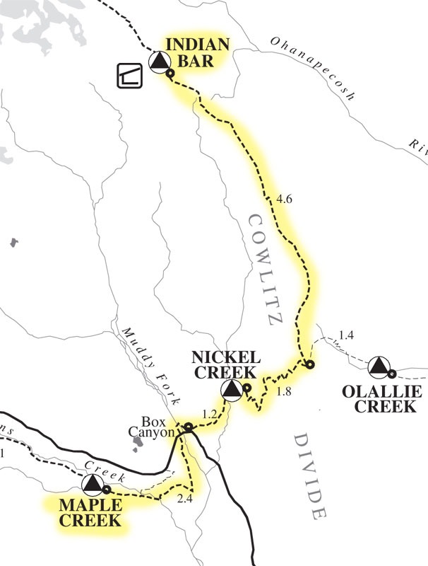
Trail Map:

Map from National Park Service.

Don't forget to click on the thumbnails to see larger images!

The Backpackers:

For this trip – we had a group of four – Nigel, Tim, Dave and myself. Tim, Nige and I did the Pasayten together last year and since then Nige completed the TGO in Scotland to hone his Ultralight skills (Or develop some contraband habits as we'll discover later ). Tim was a good sport spending a week with three brits. Dave was the newcomer and showed up to Nigel's house the day before with a five pound sleeping bag that more or less filled the entire Jam backpack Nigel lent him. Fortunately, Nigel has a gear surplus and was able to kit him out to be in the ballpark. Our start packs with 5 days of food and full water, weighed in at 23lbs (Brett), 25lbs (Nigel) 26 lbs (Tim), and 27 lbs (Dave). Dave scoffed at our running shoes and opted for more sturdy boots without poles as he had a shoulder injury and didn't want to impact it too much.


tim-150

Tim Ahlers


brett-150

Brett Marl


nigel-150

Nigel Ellis


dave-150

Dave Nettleton


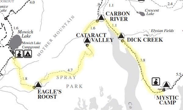
Mowich Lake -> Mystic Camp (13 miles)

Continue reading

Back from Wonderland

We're back! We had a stunning trip on the trail. Thanks to Tim lugging his huge SLR around the trail – we ought to have some excellent photos to show also once he processes (digitally, in lightroom) them. A big storm is heading for Rainier this weekend – with 1-2 ft of snow down to 6,000 ft. Trail-finding in snow around Klapatche didn't sound much fun – so we compressed the last few days and got out 2 days ahead of schedule. The trail was spectacular, every day brought something unique and different. Including a few side trips – we figure we cleared over 100 miles and about 24,000 ft of elevation. I definitely want to go back and section hike some of the areas that we're socked in due to the storm yesterday – but they we're still pretty none the less. Oh – and I think my teeth are stained from all the blueberries I ate. 🙂

I'm looking forward to going over the notes and writing up a trip report in the coming weeks…