
Swept to sea
It was 2:13 am and the tide rolled in fast and hard. The first set of long crashing waves breeched the lower walls of our tarp tent and rushed in – soaking our sleeping bags with the sea. We woke suddenly, but knew just what to do. We had rehearsed the emergency plan in our minds. We both quickly evacuate the tent, leaving our gear inside. We are lower on the beach than Bill & Tim – so must alert them too. Theresa's job is to roll the rocks off the pegs and free the lines, while I drag the entire tent and its contents to higher ground. There we will collect our wet gear and take the emergency scramble up the steep cliff to the bluff. We will assess the situation in the dark and decide if its safe to go back and retrieve the food.
The plan stumbles at the first milestone – I'm bolt upright and frozen with panic. It's pitch black. My hands grope the outside of my sleeping bag – fearing the worst. The only sources of moisture are the sweat on my brow and the condensation on the tent walls. I quickly realize it's a bad dream and am relieved that things seem dry.
The sound of the waves crashing outside is very loud and the threat still very real. I unzip the the netting of the tarp tent and shine my light outside to assess the situation. I can't see a thing – the night fog is thick and heavy. I look at my watch – 2:14 am. High tide is at 6:00 am and the alarm is still set for 4:00 am to assess the break-point two hours prior to high-tide. I decide to try to relax and get back to sleep – there's not much point checking now.
Keeping Watch
My watch beeps. It's 4:00 am – I know my duty and the vivid impression still in my brain motivates me to perform it. I crawl out of my bag – put my wet shoes on and walk around the tent. It's still slightly foggy, but the visibility is much better. I can see where the waves have been hitting – there is fresh seaweed in a line up the beach. It's not quite as far it was two hours after high tide last night – and there's a good eight-foot buffer of dry sand still between us. Confident that high tide won't affect us, I whisper across the sand to inform Bill, crawl back into the tent and fall sound asleep.
Morning breaks and we are dry. There is a light drizzle in the air that doesn't motivate us to get going – but I'm still wired from a restless night. I got in search of the food bag and find it untouched. I'm relieved – as if even a short bear stood on tip-toes he probably would of had a feast last night.

The drizzle pauses – enough for us to eat breakfast and pack up a wet tent. We head out of the cove around 8:30am and climb the ladder back onto the trail. Despite the edge of uncertainty – I really enjoyed the solitude of the off-the-beaten track campsite. Given the choice, all of my camp sites on the West Coast Trail would have been this way.
Up on the trail – the drizzle was very light and we didn't feel it in the shelter of the forest.

On the trail again
We passed through the Indian Reservation (IR 2), and slogged through yet more mud. It was tough going, and the rain from the previous day and helped refill the mud pits.

We eventually hit the beach access and were excited for some long sections of beach today. Finally, the trail was going to give us some easy miles.
The drizzled cleared up and the fog started to lift – we hiked the beach towards Tsusiat Point (pr. "Sue-See-At").
The beach was easy going and we made great time to the point. We met several hikers coming the other way – many of who were wrapped up in Gore-Tex – so we assumed there must be more foul weather ahead.

Around KM 28 we ran into a rock full of seals. They were not as loud and boisterous as the sea lions, and just stared at us as we passed by.
Tsusiat Point
Around 10:30 am, we approach Tsusiat Point, otherwise known as "hole in the wall" – for it's sea arch formation.
We hung here for a while and took a few snaps. I noticed a cave off to the side and followed it inside to explore. As I started walking back to the cave – I noticed a fresh set of Cougar tracks going along the beach and into the cave. There appeared to be just one set going in, and none going out – so I didn't venture too far into the cave. Spooking a sleeping cougar didn't seem like a good plan.


After the arch, we kept hiking along the beach. We approached another large pod of seals on the rocks. While we were watching them, a large group of hikers came by heading South.
As is customary on the West Coast Trail the group stopped and asked us for advise of the trail ahead. Their plan was to cross the narrows today and camp at Cheewat – but were concerned about the voluntary ban. We told them that Monique, Dwain at the Nitnat and even the park rangers at the light house had suggested that it would be fine to camp there in a pinch. We reminded them to bring fresh water – or plan to fill up at the little spring outside Cheewat camp. Their enormous packs looked painful – I really could not imagine not doing the WCT Ultralight.
Tsusiat Falls
After a few more klicks on the beach, we came upon the magnificent Tsusiat Falls at about 11 am. I don't think I've ever been on a hike and seen such a large water fall such as this spilling out into the ocean. [Maybe I need to explore Hawaii some time :)]

We stopped near the plunge pool and the sun came out to play. It was a nice place to rest for lunch and wash some of the grime off our legs. Despite the pretty falls – it didn't look like the nicest place to camp. There was a lot of litter around – discarded fuel canisters, old pan sets, tin cans in the fire pits. In addition a large flock of seagulls has taken up residence and so the beach was covered in feathers and poop.
We ate another feast like at Logan – salami, crackers, cheese, jerky, dark chocolate – all the goodies came out. We knew now that we were almost a day ahead of schedule and so could tuck into some of the extra days rations. Tim even found some extra supplies of Beecher's cheese in his pack.

We took a slow lunch and enjoyed the warmth of the sun. Eventually the clouds won and the sun hid behind them. It was time to move on.
From the falls we had to get back onto the forest trail and climb the ladders. To get to the trail head, we needed to first cross the river coming out of the falls.
Luckily there was a large log down over the river – it even cam equipped with a hand-rail tied onto the side.

Unluckily, the hand-rail was in disrepair and had fallen off to the side. Tim thought this might be a great opportunity for one of all to fall into the river – as it had been several days since the Double-Turtle prize. He raced over the log and got his camera at the ready.
Sadly (for Tim), we all made it across just fine and were on our way – up the ladders and back into the mud.
Not longer after we had ascend the ladders, we came to a crossing were you could walk down to get to the top of the falls. The water was moving fast from all the rain – so we didn't venture too close to the edge.
From here also, there is a trail that heads north to Little Tsusiat Lake. Hard to imagine, but we did talk to one group at Camper who got lost here and ended up taking a substantial detour to the lake.

The forest trail to Klawana River was muddy, rooty and uneventful. The cable car crossing over the river was one of the longest. My cable-slapping technique was incredibly handy here and allowed for tremendous conservation of energy.
After the cable car we hit the beach at the right time. The tide was just on it's way out – but low enough for us to hike the beach.
On the other side, as we started to hit the beach – Tim found an excellent rest-spot. He stretched out in the Hammock, while I performed a little preventative blister maintenance.

During the beach hike, something romantic got into me. I drew a huge "Brett loves Theresa" sign in the sand with my poles. Tim asked us to pose for a picture.
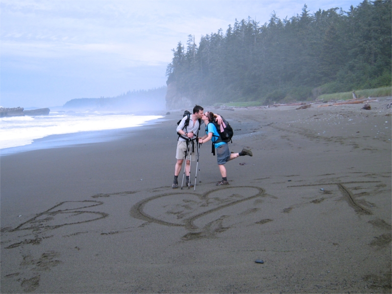
Then it struck me that we could re-use the beach graffiti and turn it into a "Bill loves Tim" picture too:

I'm not entirely sure what Tims wife (or Bills girlfriend) would make of that – but the boys were getting awfully close after being couped up in the tent so much.
It wasn't long before we arrived at Trestle Creek. We passed another group from Seattle here and in our haste forgot to look for the anchor on the rocks. The tide was so high, we probably would have not seen it anyway – but we were sorry to miss it.
We re-filled out bottles in the creek. The water was dark and brown, but we were thirsty by now. Just after we put our bottles away and got ready to get back on the trail – the even darkening clouds opened and down came the rain.
By now, we were expecting the forest trail to be getting easier, but to be honest, we didn't feel that much difference between these sections and sections on the southern parts of the trail. They were all just mud and roots, mud and roots. We slogged through it and made our way in the direction of Darling.
Poles and Umbrellas
Up to now we had been struggling with the choice of Poles OR Umbrella. On this section – Tim perfected the "both" technique.
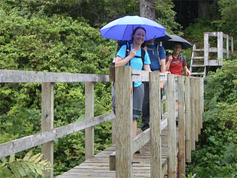
The trick was to use the chest-strap of our backpacks and jam handle of the umbrella into it. I don't normally use the chest-strap and it was a candidate for removal prior to this trip. Now I plan to keep it around. With the umbrella handle in the strap and pushed to the right – it generally maintained it's location without touching it. Occasionally it might shift if a bush or tree from above hit the umbrella canopy – but a quick adjustment every 400 yards or so was a small price to pay for the freedom of ones hands. Using the technique, we could use our poles still to move through the thick wet mud with ease and still remain dry from the heavy downpour.
The forest trail followed the cliffs high above and afforded occasional views of the ocean, and the infrequent sound of growling sea lions. After a few kilometers we came across another donkey engine and then an old grader used to make the trail.
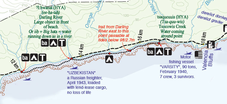
Valencia Bluffs
At KM 18 we arrived at the Valencia Bluffs.  It was raining hard, was high tide and the ocean was fierce. We looked out over the spot where the Valencia went down. This is the reason that the West Coast Trail exists for us to enjoy today. If it had not been for the terrible fate of the people whom died that day and the countless wrecks before and after, we may not of had the privilege of experiencing the beauty of this place.
At lower tide you can apparently see some of the wreckage left behind. The tide was high and pounding. I looked down at the rocks 100ft below and imagined being stranded down there. It looked terrifying – and there was no where to go. The cliffs on all sides were steep and impassable – there would be no way – even for the extremely fit and brave, to climb out of that slippery trap.
Theresa brought my attention to a large dead tree that was leaning against the cliff. It went beyond the cliff and and all the way down to the rocks. Nailed into the tree trunk every 2 feet were short sections of very old and moss covered 2×4. I wondered how old these were. Perhaps they were put there in the early 1900's shortly after the disaster as a way for future survivors to have a shot at climbing out of the trap. It was a long way up and the cross braces seemed deadly – I wouldn't want to have to make that climb – but it if were the only option, I may be thankful. But then were would you go? To be stuck in the wilderness with no food or water, no idea of the best direction to go in – North, South or East. Probably wearing evening wear.
It was a sobering rest point.
Valencia to Darling
The forest from Valencia to Tsocowis blew by. At this point we were in the rhythm and had our combo pole/umbrella technique down.

It poured and poured. We past many hikers coming the other way – they were soaked in heavy saturated Gore-Tex or dripping ponchos covering their packs.
Many groups looked at us at first like we were space aliens. Who the hell trots along one of the worst terrains in North America wearing a T-Shirts and shorts, sporting an Umbrella? Within seconds the space alien stares start to fade and are replaced with a light bulb going off. OMG – these guys have an Umbrella – what a brilliant idea. Why didn't we bring one of those? It was a fun and predictable reaction each time.
We we arrived at Tsocowis, we considered the beach option – as the forest was getting tiresome. Unfortunately, as was the story with most of our trip – the tide was once again against us. We could not pass the headland due to the current tides. Our choices were to wait a few hours for the tide to drop, or force ourselves back onto the forest. We were in the mood for keeping our bodies moving and the forest trail – while "same old, same old" wasn't that unbearable.
A Darling Crossing
We popped out of the forest near darling and had to scramble of a wet, slippery log jam in order to reach the river. I searched up and down the river for a few minutes looking for a set of stepping-stones we could cross on. There were none. It wasn't deep – a foot at most, but deep enough to get wet feet. Our feet were already wet from the rain – except Theresa's – the only one of us with bone dry feet still. I pushed across, and the others quickly followed. The water was cold, but soothing on the feet and the other side we knew brought a delightful beach hike to Michigan. A nice gentle beach stroll, right?
An Epic Beach Crossing
The beach hike started out rough. The tide was very high and was still on its way in. It left very little beach for us to navigate in spots. We were forced out of the sand onto slippery rocks – large and medium sized boulders that bruised the feet after a klick or so.
Blisters & Bliss has an infamous quote in it that we used over and over again on the trail – "Get your cameras out – the folks back at the office will never believe this one." It was written in reference to the incredibly deep mud pits and how crazy they can get. However, for our adventure – we recycled the phrase for what was about to follow…
Not too far from Michigan we came upon an enormous log jam. Log jam doesn't really do it justice – it was more like an entire forest blown down on the beach. We scrambled over many of trees until we came to the enormous one in the middle. Probably the one to fall and bring them all with it. We couldn't go around it – as the waves were washing up around it's root ball. We couldn't go over it easily as it was incredibly large and slippery. We couldn't go under it – as it was resting on it's thick branches on top of piles or yet more logs. It was raining hard – cats and dogs even. We were trapped – no where to go. Should we risk wading into the ocean to get around the root ball? The waves were large and crashing hard close to shore. Bad idea. Theresa and Tim were further back. Bill and I scoured the tree and eventually found a possible hole. We moved some large branches and logs out of the way – and it looked like we could squeeze through. The umbrellas went away and the packs came off. I dove into the hole under the tree trunk – flat on my belly and wriggled and squirmed until I got out the other side. Bill threw my pack over the top of the trunk. It was treacherous and slippery everywhere. And so we went – one at a time. It just seemed so ridiculous at the time – something staged by a crazy reality TV show – "West Coast Challenge" or some such. But we all emerged unscathed and soaked from the lack of umbrellas and the belly-crawling. We had escaped the log-trap-of-death and only now wished we had taken our cameras out. There was no doubt in our minds – people will never believe this one back at the office!
Michigan Camp
We were on a mission! Our feet were soaked, our clothes now damp for the first time and our morale fueled by completing the impossible.

We rounded the corner in the pounding rain and saw Michigan Creek. We could see tents and tarps on the beach and a few people watching us from the balcony near the out house. We were moving fast now – all four of us in a close line – still sporting umbrellas, without hesitation we all waded into the creek and out of the other side. The folks watching must have thought we were nut cases. Our objective was to wilderness camp beyond Michigan somewhere.
It was only 5:30pm and we paused to chat with hikers at Michigan and it turned out to be not as crowded as we expected. We discussed our game plan. The idea to wilderness hike still had some uncertainty of finding a place before nightfall. The hikers we talked to said they didn't see anywhere suitable for camping on the way in. So we decided to stay put. We only had 12km to do tomorrow before the trail bus arrived at 1pm – so were confident we didn't need to push on to make it.
We setup camp in the rain and quickly got dry. Theresa was a little cold, so I made her a hot-water bottle by putting hot water in a platypus bag.

Bill and Tim found a great campsite – right in the middle of the trail! The other official camp spots were giant puddles. It seemed unlikely many more people would come along the trail tonight.
We ate a well deserved hot dinner and the rain stopped on the beach. The clouds started to clear a little before darkness fell and the ocean waves relaxed.
It did however, continue to rain inside the trees – as they shed all of their water from hundreds of feet above.
After cooking and washing, putting the food in the bear box (which some lame person had used to discard all of their trash) , I crawled into the tent to join Theresa.
With two stream crossings, and a day full of heavy rain – I suspected my feet might need a little TLC. I pulled of my socks and lo and behold – had achieved the delightful status of West Coast Trail "swamp feet".

Brett, your writing is delightful and your photos do a great job of painting apicture of the rain, wet… and maybe even a bit of sun that you encountered along the WCT. You might like to know that I’ve set day4.foggy.beach.8×6.jpg as the wallpaper on my machine for it’s a great shot.
– Sam