Trail Name: Eastern Pasayten Loop
Distance: 65-70 miles, round trip
Elevation Gain: 10,000+ ft
Date of Trip: July 13th – 16th, 2008 (3.5 Days)
Permit Info: An overnight permit is required, but can be obtained from the Trailhead; no advanced reservations necessary. Northwest forest pass required for parking.
Getting There: From Seattle, take I5N 62 miles to Highway 20 (Exit 230), then east 128 miles to Winthrop. At Winthrop, turn North on West Chewack River Road which becomes FR #51 a (Amazingly well maintained) gravel road. Follow the main road all the way to the end – at Thirtymile Camp.
Trail Map:

Map from Backpacking Washington.
Don't forget to click on the thumbnails to see larger images!
Pre-Trip Notes:
We chose this trip due to a heavy snow-year in the Seattle area. In early July 2008 most trails that would be open were not accessible due to a heavy lingering snow-pack. The Pasayten Wilderness area in Eastern Washington melts out early and is amazingly void of crowds.
Day 1: (July 13th, 2008)
We left Seattle at about 8:15am. As we loaded up the packs into the back of Tim's land cruiser I noticed all of the Platypus Hoses hanging out: "Make sure you water doesn't leak" I quipped.

The drive was both beautiful and fast – it's a very pretty drive through the mountain passes to Winthrop. We arrived at Winthrop around noon. Our target destination was the Brew Pub for lunch. Sadly it was closed due to renovation – so off we went to the duck inn for Mexican food and beer.
Follow the link below for the rest of this report.
Around 1:30pm we were on our way to the trail head. The road in was amazingly good and void of any potholes. We wondered if it was in such good shape as it is seldom used. The green trees broke and soon we were driving through a heavily burnt forest area.
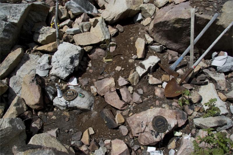
A few miles before the trail head we passed a roadside memorial. It was in memory of four firefighters who were trapped here in 2001.

They were so young – it was a humbling and somber experience to witness their graves.
A few minutes after getting back in the car, we arrived at the trailhead. Not a single car in sight. Being a Sunday, we expected some other day hikers at least – but as we would find out – it probably wouldn't be the best day-hiking area. As we unpacked our bags – Nigel discovered that his platy nozzle had fallen off his hose and his bag was soaked. Always a fun start to the trip. 🙂 Should have listened..
At 3pm we were on the trail. It was hot – mid 90's. One missed-opportunity

that we need to remember for next time is to not pack in water from home. Our water was warm after being in the car for 7 hrs, it would have been smart to fill up with cold water from the creek at the trailhead instead.
The trail crossed the Chewuch River on a sturdy iron bridge and starts out contouring the river. The goal today was to hike 6 miles to a Campsite near the Junction of Fire Creek Trail.

Here's a Thanks-To-Bill contour-map showing the route following the Chewuch up the valley:

[It also shows our exact point of travel in blue (outbound and return) with the GPS tracking information taken from my Easy Showily device.]
The forest is no more here and only the charred trunks of trees remained. I kept thinking of those firefighters and what they experienced. As far as the eye could see there was hillside after hillside of burned-out forest.
After a little while we passed an old burnt-out sign – we tried hard but were unable to make out its old charred markings.

The trail was nice and wide (apparently an old stock route) and a flat to gentle grade. However, it was rough going in spots – there were lots of blow down and multi-tree clusters to scramble over. It clearly had not been maintained this year – and judging by the lack of broken-twigs on the trees that were down it probably doesn't receive much traffic. It was also hot without the shelter of green canopy overhead.
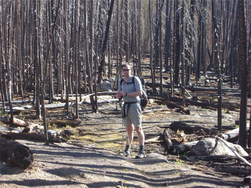
At first I felt great sadness for the burnt out forest we were in. Shadowed by the grounding tragedy of the lost firefighters – it felt like a terrible and destructive thing to have swept the area. The lack of wild-life and desolation was very apparent. We talked about the fire as we hiked and Tim shared some knowledge he had on forest fires – the way that the sap in the fir trees super-heats in the fire and spits out of the top of the trees spreading the fire quickly. The way that fir cones are normally closed but full of seeds – fire activates the cones, opens them up and disperses the seed on the forest floor. As we talked my mood changed and I began to see the great beauty and power of a natural forest fire. While temporarily damaging to the area, the fire is not devastating – but on the contrary – rejuvenating and cleansing. Natures way of re-balancing the ecosystem and putting nutrients back into the soil for the next generation of forest. I began to look at the burnt out forest with great admiration for natures amazing design.
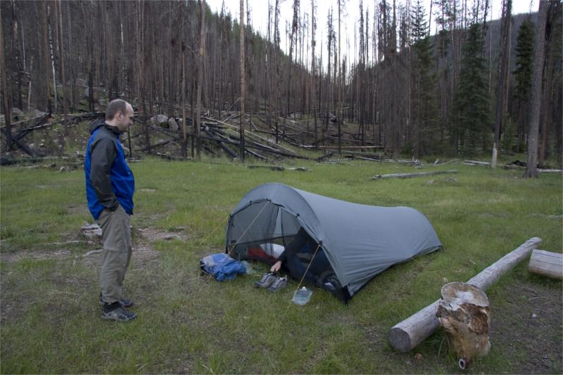
Just before 5pm we arrived at a clearing before the Junction to fire creek trail. The area was beautiful – the burnt forest floor in this area was successfully rejuvenating itself and lush grasses were around. Against the back drop of the black trees and the deep blue sky it was a pretty area.

There were two camps in this spot – with lots of flat areas for more. It was still early, but we weren't sure of a better camp spot upstream so decided to stop here for the night.

After we setup tents, treated water and ate dinner – around 8pm we saw a group of 3 guys come up from the same way we had. They stayed on the trail and marched past our site area headed for their destination. We wondered where they were heading and where they would camp for the night.
After futzing with hanging our food for some time (we found the *perfect* tree, but our cords were too short) we eventually found good spots and decided to hit the sack.
Nigel spent a little time staring at the Tarptent, with a kind of "I'm supposed to sleep in that thing?" look on his face – but eventually he caved and crawled inside.
The bugs at this camp were minimal and didn't impact us at all, there was also great access to the nearby river for water.
Despite the roaring 95-degree temperatures at the trailhead – at night it got quite cold. It got down to about 38 degrees and I had to put on thermals and a hat to keep warm in my WM Highlite bag. Nigel brought a winter bag and was toasty-warm all night.
Brett, a wonderful first installment to a hike in a gorgeous location. Thank you as always.
Pingback: dooger.org » Blog Archive » Tungsten Mine at Wolframite Mountain (Pasayten Wilderness)
Really enjoyed your site. Wonderful pictures. I was up at Tungsten Lake in about 1993. Saddened to see the fire damage, but the Pasayten is still terrific.
Brett, enjoyed reading about your trip in the Pasayten. I’m planning to be a little west of there on the PCT b/w Slate peak and Canada, then heading back south on Buckskin Ridge. Do you know anything about trail conditions there or can you point me towards any good resources? The ranger offices were less than informative and their website only has a little info about a month old. The PCT website has no good trail info. Basically I just want to know if i’m gonna need to bring an ice axe or anything like that (especially since I don’t currently own one or have any experience using one.) A guidebook I read mentioned that it might be necessary to bring one. Thanks for any help you can provide!
hey sam,
the pasayten is the only trail i’ve done in the area. for first-hand trip reports check out http://www.nwhikers.net/ if you aren’t familiar with it. usually great beta on trail conditions.
i should think that area is snow free by now – esp. this year – as june was unusually hot. and no point in taking an ice-axe if you don’t know how to use one! make sure you take an ice-axe arrest class if you think you’ll need one….
enjoy – and let me know if you post your trip report somewhere… always looking for new finds…
cheers,
-brett
do u have any picture of tungsten lake?
rob – i don’t sorry – it was down in the trees and wasn’t that visible from the trail if i recall…
Pingback: Brett on Stuff » Wonderland Trip Report – Day 7
Where did you get the cool 3-d views of the topo maps? That’s a really nice way to get a view of the terrain. I’m imagining a tool where you can zoom in/out change “camera” position in 3 axes?
We’re looking at the Pasayten in a few weeks, your site has been really helpful. Plus, I’d really like to do the ultralight thing, if I can convince my 4 hiking buddies not to just “split the bill” on the total weight at the trailhead.
Thanks!
Allen
Allen,
See this post for where I got the Topos from:
http://www.brettonstuff.com/index.php/backpacking/a-backpackers-dream/
I’d also recommend http://www.redtrails.com for great trail gps data.
Enjoy the Pasayten! I’m jealous!
-B
The location that you chose is fantastic for getting a feel of outdoors. Not to tough but certanly not that easy. Great photos you took. Thank you for the nice post.
Pingback: dooger.org » Eastern Pasayten Loop