Great article from backpacker.com on how climate change has impacted Mt. Rainier in recent years. Follow this link to read.
Mt. Rainier is crumbling into the sea?
Leave a reply
Great article from backpacker.com on how climate change has impacted Mt. Rainier in recent years. Follow this link to read.
End looks like an interesting company.  End stands for Environmentally Neutral Design , and they go out of their way to use the greenest materials and processes possible.
More interestingly, is that they have an 8.5 oz shoe. They look more of a street shoe than a trail runner to me, but they certainly peak my curiosity.
REI is stocking some of their shoes, but more info can be found at their website:
Nigel Posts his TGO Challenge Route here.

Windows Live Writer (which I use to post and edit my blog), shipped it's Release Candidate today as the official 2009 release. After the Vista fiasco, I was starting to loose faith in MSFTs ability to ship decent software. The Live Writer team has given me hope again – it's been a solid product from the start (with a good plugin-SDK backing it up), but it keeps getting better – especially with this release.
Cool new features?

Kudo's to the Live Writer team on a great release – I look forward to using it more.

This has been an agonizing decision for me over the last week. Several conversations I have had with Theresa have made me re-assess my current plans to travel to Scotland and hike the TGO in May. There are many many reasons I really want to do the TGO (not least of which, it's on my Top-5 list), and a handful that give me pause for thought; but it boils down to two major factors:
So with much sadness, I am withdrawing from the TGO. I am thankful for the opportunity to be accepted onto it this year, and hope that Nigel and Lynn at least (Tim will likely withdraw also given this news) will see their way across Scotland. I very much hope and wish I hike the TGO some day when the planets align to make the circumstances right.
I shall turn my attention back to my top-5 long distance list and pick a long distance hike closer to home this summer – perhaps this is the year for the Wonderland Trail?
I'm so excited!
At a recently family reunion, I got chatting with a relative of Theresa's from California about Thai Food. I talked about the magic of the Kaffir Lime – to my amazement she proclaimed "Oh – we have a Kaffir Lime bush in our garden." …

I even went so far as trying to grow my own tree, but sadly that wasn't happening in our climate. Kaffir Limes are hard to come by in Washington State. The FDA hasn't approved them for produce sale (According to the grocer at Uwajimaya) and so at Asian grocery stores – all we can get are the Kaffir Lime Leaves, not the limes themselves.
When making thai curry pastes, the peel of the Kaffir Lime imparts an intense amazing flavor that really sets them apart from other curries.
Today, I received a shipment of their Kaffir Lime harvest! They are perfect, beautiful and smell so wonderful!
The timing couldn't have been more perfect. After maxing-out on my last plate of turkey left-overs, I'm ready to cook some more Thai Food.
I'm going to make a beef Panaeng Curry from scratch (making the paste itself) in the next few days to take advantage of these deliciously fresh limes.
WordPress 2.7 is out. Upgrade was trivial – took 10 seconds to unzip and copy the files, it automatically upgraded the database when I logged into the admin site. Staggeringly easy. Nice job wordpress team. I look forward to poking around a bit more in the admin UI – although I don't really use it for editing anymore as Windows Live Writer works better for me.
What point is there in hiking the TGO
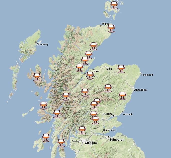
without a map showing the location of some of the worlds finest distilleries?
To that end – Nigel conjured up this map for all to enjoy.
In a search for an ever lighter backpacking knife, I ran across this beast:

Weighing in at a whopping 2 lbs, and retailing for a princely $1400, this knife has every attachment ever conceived – a total of 87 blades and 141 functions!
Some of my favorites include: Magnetized recessed bit holder, Chain rivet setter, Universal wrench, Springless scissors with serrated self-sharpening design, Golf Club face cleaner, Shoe spike wrench, Divot repair tool, a Ruler, Cupped cigar cutter with double honed edges, Watch caseback opening tool, Compass, Fish Scaler, Hook disgorger, Shortix laboratory key, Laser pointer with 300 ft. range, Flashlight, Special self-centering screwdriver for gunsights, Mineral crystal magnifier, Tire tread gauge and Fiber optic tool holder.
How I ever went into the wild without my Shortix lab key, laser pointer and gunsight tool I will never know.
Anyway… if you're tired of losing all your money on the whims of wall street and want something to show for your hard earned cash, then perhaps this is the blade for you! Might be handy when the economy melts down and we all run for the caves…
You can find one here.
I started a Custom Google Map of the TGO challenge. I'll put points of interest and things on it, as I find them from reading various things online.
Currently it has start points, end points and some restaurants from Andy.

Map is located here.
Tim had a busy weekend he worked on the Pasayten Photos he took on our trip and make allsorts of tweaks and adjustments to the RAW format in Adobe Lightroom.

The results are spectacular – and make the ones I posted in the trip reports seem washed-out by comparison.
There are some epic photos in here that make jaw-dropping backdrops for your PC desktop.
Given that he posted the originals on Smugmug, I'm sure he wouldn't mind of people snagged one or two 🙂
>> Link to Tims Pasayten Photos
I received a letter in the mail today indicating that we have been accepted onto the 30th TGO Challenge taking place in May 2009.
This year there were 509 applications and only 360 spaces available. We were lucky enough to get selected in the draw.
Planning our trip will be fun and challenging. Nigel found a good Podcast offering some planning trips by Chris Townsend:
Chris Townsend TGO Route Planning Podcast (48 minutes)
Earlier this year I looked into Ultralight GPS Units. I ended up trying out the Garmin Forerunner 405, but wasn't thrilled with it. I liked the watch form-factor, but it was clunky to use and was missing an Altimeter. It also came with a weird USB-cable which made field-charging it somewhat difficult.
In the end, I decided a basic GPS logger is all I needed. A GPS logger will record waypoints – show basic lat|long information on a screen and they usually run on easily field-replaceable batteries. It doesn't come with a fancy color screen and map data like the traditional GPS units.
The Easy Showily , as awkward as the name might be – came up trumps. This is a deceptively excellent device.

First and foremost – the device is incredibly small and light – weighing in at 1.3 oz without batteries.
Secondly – it has amazing battery life. I used AAA Energizer Lithium Batteries and got over 20 hours of logging-time per pair. A pair weighs in at 0.3 oz.
Digging a little deeper – the cap comes off and reveals a USB plug. The device is elegantly simple – in that it does not require drivers or special software to operate. The USB connection exposes a typical thumb-drive (albeit with a meagre 5Mb of storage), and as the GPS unit logs data, it simply writes the way points to a file on the drive.

When you insert the device into a PC, windows detects it as a Thumb Drive and auto-runs the Win_Tool.exe application installed on the thumb drive. This application proceeds to unpack the data file into many different formats – a GPX file – the most common GPS exchange file format, and a collection of HTML and Javascript files that it then proceed to open a browser on – which uses Google Maps to display your way-points. I get all the benefits of Google Maps terrain data without needing to install special mapping software on my machine.

A side-bar allows you to show each GPS ˜track' (a collection of way points), and overlay other information – such as ˜push-pin' data, direction, speed etc.
Ideal for multi-day trips, the Easily Showily can store almost 100,000 way points. When logging aggressively – as a way-point every 10 seconds – that's over 23days of continuous data assuming 12 hrs of hiking a day!
It's chocked full of other features like power-saving shake-activated mode, photo-location-tagging software, multiple recording modes (bike, walk, run, car etc) and more.
Costs about $99 from ˜Buy GPS Now'.
And the point of carrying a GPS? So I can easily crank out maps like this one of our Pasayten Trip.
It was 4am and it was cold. My watch was reading 38 degrees in the tent – chilly when you consider the daytime was in the 80's.
It was a rough night; and my sleep pad felt thin – I forgot to take my usual nighttime dose of Tylenol PM before hanging the bag for the night. I shut my eyes and tried to get back to counting sheep, or mountain goats maybe.
Eventually 6am came and the sun came up brightly through the trees and started to warm things. We expected to have a cold breakfast as we thought the sun would come up late – hidden behind Amphitheatre Mountain, but it rose perfectly between the saddle and hit the campsite early.
I got up to warm a little in the morning sun, and got some coffee going. The bugs weren't bad this morning, so it was nice and pleasant sitting out on the rocks.
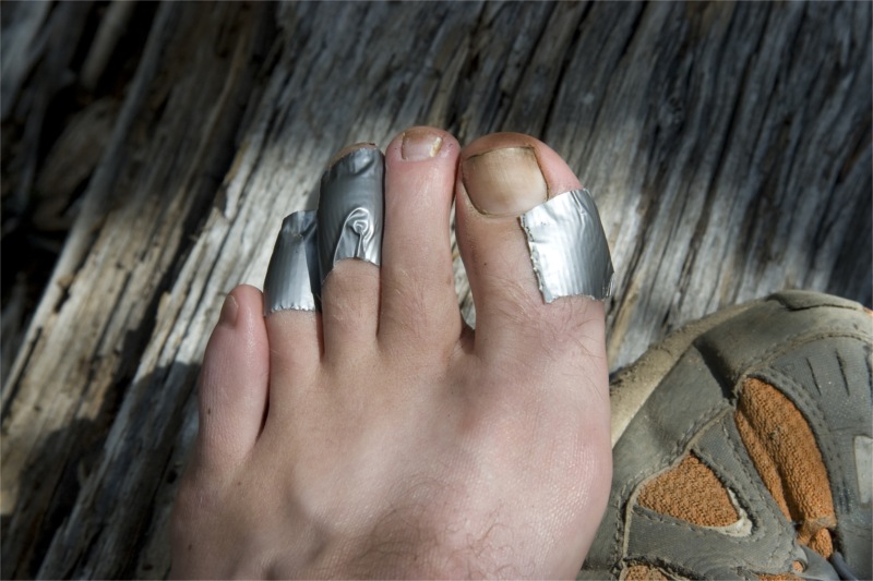
We ate breakfast, did camp chores and then spent a while doing extensive foot repairs. We debated if the best option for my now liquid filled blister was the lance the skin and drain the fluid or not. The fluid supposedly serves as nature protection – but it sure makes things feel less comfortable with a swollen bulge in your shoes. We decided to leave it intact at least for now. Plenty of duct-tape and gauze later and we were all ready to roll. Nigel and Tim were sporting some new foot-sores now too – so they deployed some preventative measures of their own.
Just before we left camp, my satellite pager went off. My heart fluttered with fear. Surely Theresa can't be going into labor we're too far from the road to evacuate in any reasonable time. I checked the message and it was indeed from Theresa – but just some sweet words of encouragement. It was a cute to get messages from her on the trail – kind of like being in primary school getting little love-notes passed from another classmate with a crush; but also weird to receive them one-way and not be able to text-back.
We left camp around 8 am and decided to take a ˜shortcut' to Remmel Lake that was marked as hard to follow on the Green Trails map. We went off in search of the shortcut.
The ˜hidden' trail was rough going at first – not that it was hard to find, but it wandered through a marshy area with heavy horse damage on the trail – so there was deep unpleasant mud to walk in. After a while, the trail did start getting a little trickier as we climbed up into a rocky area with little vegetation. It looked like one could do a neat side-trip here up into a saddle that appears like it would look down into the Amphitheatre. However, we elected to continue on.
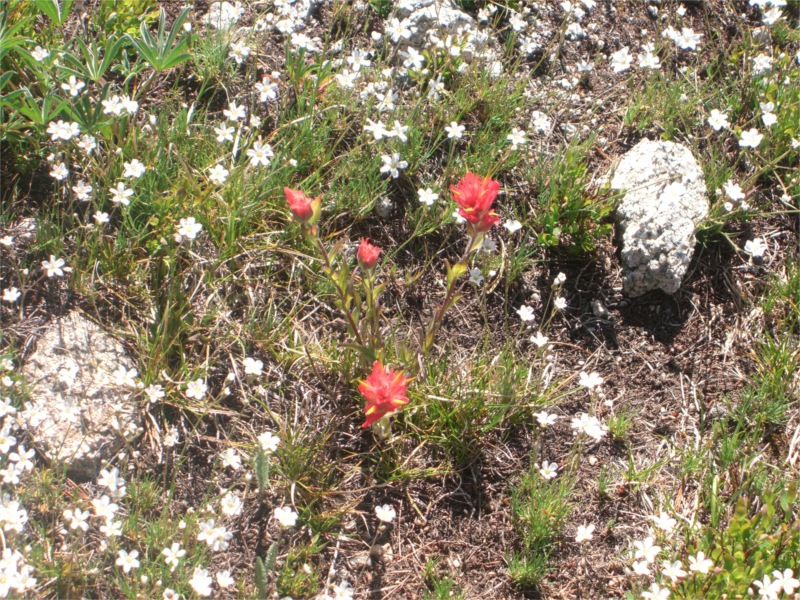
Eventually we re-found a trail and it popped us out into a stunning meadow area, with breathtaking views all around. A small stream ran through the base of the meadow and I broke off from the group for a while to get water from the stream. Walking back towards the group, I realized that the ˜grassy looking meadow' I was in, was actually thick with flowers with green-buds on just waiting to bloom. We were a little ahead of the curve due to the late snow melt, but I sure wish I could have seen this area in full bloom. Still – it was very pretty as it was.
Further on from the meadow area we walked into an area with what appeared to be a somewhat permanent camp. There were white tents, a propane tank and a fuel drum. The camp seemed still – and a deer was munching grass on the other side of it. We assumed perhaps the trail-maintenance crews stayed here?

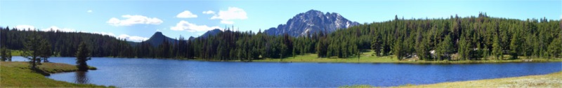
The trail descended rapidly until it dropped us out near Remmel Lake around 9:30am. Remmel Lake was wide open and very expansive. Plenty of horse damage here, but pretty none the less. There wasn't a sole in sight during our time there. I kept peering over the other side of the shore – half expecting to see some a bear or other large wild-life – but it was still as could be.
As you leave the Remmel Lake area there is a very tight hairpin turn off to the left – which is easy to miss; which is the trail leading down to the Junction to 4 point lake. The decent was long, and pounding on the feet. In true Tim style – he decided he would ˜jog' (more of a ˜sprint' in our book) down the trail and meet us at the junction. He gained a good half-hour over the rest of us by the time we caught up with him.
In Tim's absence, Nigel and I debated on what we wanted for lunch. Cheese Crackers and Salami won out again – and our plan was to snack at the junction. Half way down I had a bright idea We stopped in a chilly stream and filled up a left-over foil pouch from a freeze dried meal last night with water, and plopped the cheese and Salami (Vacuum sealed) in it. This was my trail refrigerator and had a good 35 minutes to get the cheese nice and cold for lunch. Sure – it meant carrying an extra pound of two of water – but our packs were very light at this point in the trip.

We caught up with Tim and ate lunch – out came the head nets – as lower in the woods the mozzies and biting flies came out – obviously attracted to the delicately chilled Aged Cheshire Cheese on the menu.

It was only 11:30 am and we had a choice to make:
It was tough call – four point was supposed to be very pretty, but it was really early in the day still. The long last day didn't appeal either. We decided to skip four point and push on to the first camp.

The eight miles along the Chewack valley were long and gradually descending. We arrived at camp around 3:30 pm. My blisters were burning and so I went to dump my feet in the stream to get some relief.
Nigel, Tim and Bill started the next debate
So it's only 3:30pm – which is pretty early in the grand scheme of things (uh oh a very slippery slope)

We had a few more options to consider:
We spent a good hour debating our options and repairing our feet. We'd used up all our duct-tape on blisters and were down to just a few plasters. At 4:30 we took the final poll – each of us first a first and second choice vote. The votes came out 2,0,2,4 in favour of Margaritas! So on went the packs and out came the polls.

The push out was hard work – it had been a long day so far – over 16 miles to the camp site, and we were adding another 5+ to get out. We forgot how unmaintained this section of the trail was – but seemed to brute-force our way under and over fallen trees with a feverous vigor! The power of the mighty Margarita promise!

Two hours later, at 6:40pm we arrived at the bridge we started the trail on.
This time the trail head was not empty – a forest service truck was there, and two frogmen were swimming in the river in dry suits. They were surveying fish – and had found Chinook Salmon, Rainbow and Steelhead Trout swimming upstream. We chatted with them for a while while we washed up in the river before heading for civilization and tequila.
[Apologies for the long delay in getting this written up. A newborn sure takes a toll on ones time to be able to write blog entries!]

I may well be late to the party blogging about this upcoming new toy, but it is one that I'm excited about checking out when it ships in Spring.
Can a 9 oz air mattress offering 2.5 of thick padding really exist?
Thermarest believes it can.
Will it be enough to lure me away from my current 4.7 oz solution and actually inspire me to take MORE weight? We shall see
For more details, Gear Junkie has a great write up here.

The Great Outdoor challenge is a ~200 mile hike from the west coast to the east coast of Scotland.
Entry forms are due by 10/17 (Today) for the event starting in May 2009.
The TGO is on my 5 long distance trip I really want to do list, so we submitted forms today. Hopefully we will get selected.
I might be somewhat ambitious given I have a newborn at home – but Theresa is game for hanging out with my parents in the UK with baby Chester, while Nigel, Lynn, Tim and I do the hike.
Fingers crossed we get selected – as there are many more applicants than spots available
Just when I thought I had the lightest stove possible something comes along  to shave ounces!
Roman from Lighthiker's blog has an excellent review of this new stove.
It's basically a recycled beer-can as the pot – with a Lance Armstrong style silicone wrist-band on top as a ˜pot' holder.
The weight of the pot, cone and the stove come in at a staggering 2.7 oz.
However, the full package weighs in at 6.9 oz, which isn't that great. If you look at the details – the wrist-band adds an ounce, a half-ounce for the lid and cozy and over 3oz for the ˜carry-case'.
I was sold until the 3 oz carry-case came into the picture. While this does double as a 2nd bowl – it's way to heavy compared to my 0.6 oz disposable tupperware container. 2.4 oz for cone-crush insurance isn't worth it in my book.
I got to use my new Caldera Cone Stove on a few trips this summer. It has been my first time relying on an alcohol stove in the wild.
Here are my thoughts so far:
 Cons:
Cons:
Pros:
So far – the pros far exceed the cons, and I'm really happy with it.
Without revealing my sources lets just say I had some dehydrated wine appear at my home one day last week. Sold in Europe and not FDA-approved in the USA this may be tricky to obtain – but – is it worth the effort?
Lets do the taste-test
First the goods – comes nicely packaged in a foil pouch. Weighing in a 2.1 oz – considerably less than your average 1 liter bottle, it's looking good so far

Emptying the powder into a bowl, it has a distinctive musty smell – kind of like old cork. Can't be bad, right? Perhaps it's a vintage year?

The directions call for mixing with 6 oz of cold water, and letting stand for 5 minutes.
I was rather hoping it would make more than this but I'm still hopeful maybe the powder/liquid ratio helps the alcohol content, and the taste will be more divine this way

After about 6-7 minutes of stirring – trying to get the powder to dissolve and get rid of the lumps, I finally give up and reach for the strainer.
Strained into a wine glass, the wine now has a delightful white scum layer floating on top ok I'm starting to get nervous

I try and overlook the rotting beetroot smell as I bring the glass to my lips for the taste test mind over matter, I really really want this to work out. It's dehydrated wine for heavens sake – cut it some slack.
A nice fruity bouquet, wonderful legs, earthy structure, revealing layers of ripe berries, currants and vanilla oak.
These aren't the words I would use. I tried really hard – but the following is the BEST I could come up with.
Clumpy, musty odor, like drinking beetroot juice spiked with cheap vodka that has spoiled at the bottom of the ocean for three hundred years.
Needless to say this sucker won't be going in my pack on a trip anytime soon.
I wonder if I can sell the other two packets on ebay to recover my losses
Day 3 was an abrupt start. Around 5 am – as the sky was lightening I heard a shriek from Nigel, muffled by my earplugs- "Maaaattee – wakeup – there's a mouse under your hat". Sure enough, a little field mouse had found enough of an opening in the zipper of the Tarptent that we left open to allow a platy-hose to supply water in the night.

Breakfast was another hearty Swiss Muesli with coconut milk – spiced up with some de-hydrated raspberries that Nigel's wife Lynn made for us from her garden. They were perfectly tart! We also drank a bunch of Chia Seeds to see if the extra fuel would help us get going.
We were on the trail by 8am and my blisters were already very sore. Boundary trail continues past haig mountain, around teapot dome for another 7.2 miles on the way to Tungsten Mine. There were plenty of meadows and larch trees and ever-improving views along the way to keep us entertained.

On the other side of teapot dome we found a great looking unmarked campsite with good water sources.

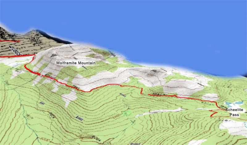
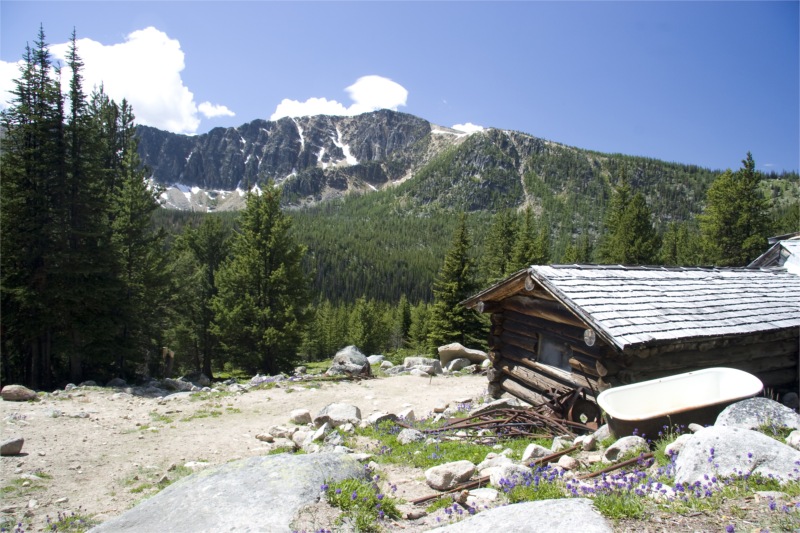
After several hours we finally arrived at Tungsten Mine.. There were a few clues we were near the mine – a stream crossing the trail with some rusty iron pipe sticking out and some other old iron artifacts. The trail forked – to the right to the upper area of the mine and the cabins – the left down to the lower area – the pit and machinery. We went right and straight for the cabins.

I love stumbling on old buildings like this out in the wild. Either old cabins, look out towers or ruins. It makes for a great time to pause and ponder the people that were here long before us.
It was around 1pm and time for lunch. We hadn't needed to stop for a mid-morning snack today – the Chia Seeds seemed to be doing the trick and sustained us for longer than usual.
The mine had two main cabins – a smaller on with an drum-stove and a larger one with more amenities.

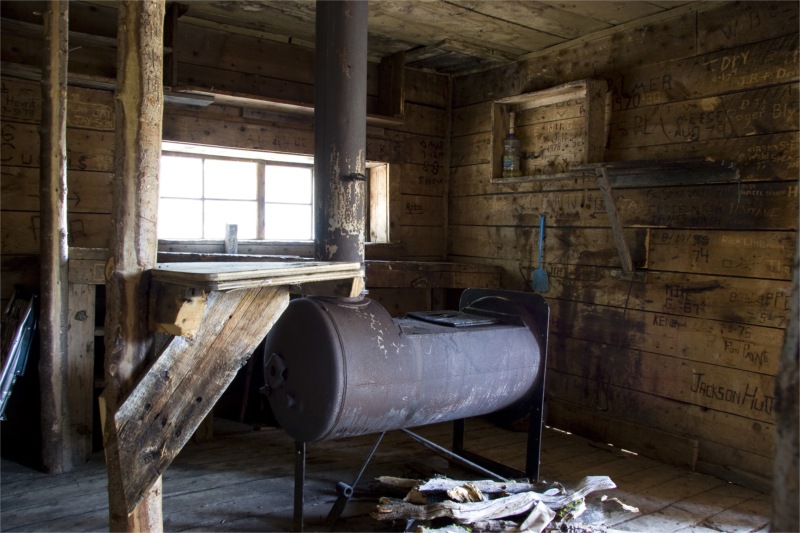
Nigel and I headed for the small one while Tim and Bill searched for water to treat. I had to sit – my blisters were excruciating now. I looked at the damage – and it wasn't pretty – both heels had quarter-sized water pockets forming – owch – we still have a long way to go.


We explored both of the cabins and then wandered down the hill to explore the mining area. The views of Apex Mountain from the mine shaft opening were spectacular. I can think of worse places to work each day.


For more details on Tungsten Mine, Nigel has an excellent write up here.
The only sad part for me about the mine area, was all the graffiti in the cabins. So many name carvings in the old logs. Some people have been more thoughtful and carved on wood plaques and hung them instead, but not nearly enough.
I was also shocked (no pun intended) to see remnants of Knob & Tube electrical wiring. I was surprised that they would have electricity all the way out here.

After several hours of exploring the mine, we started to move on. The guide suggested that water was scarce between the mine and cathedral lakes; so we loaded up all of our Platys at the Mine. Nigel and I rock-paper-scissored for who carried the water load. Nigel won.
A half mile from the mine, I was trailing behind the pack – wobbling slowly on sore blisters. Nigel took pity on me and ended up taking the water load anyway.
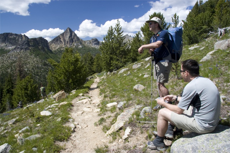
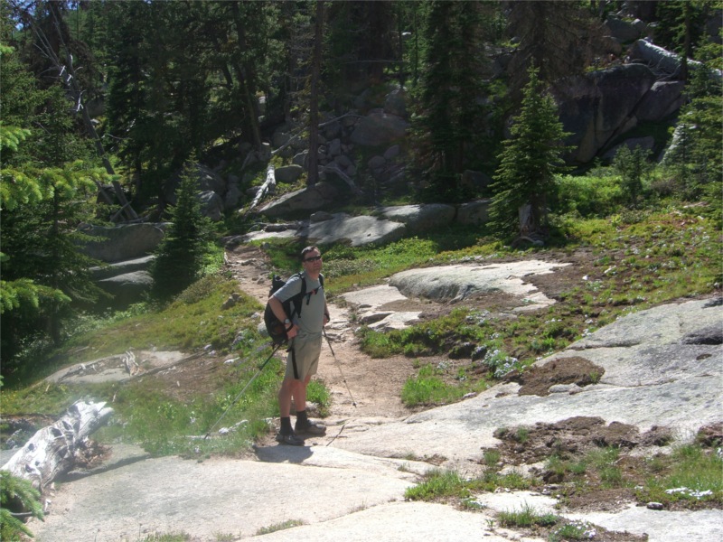
The trail between the mine and Cathedral pass is stunning. A miles or so after the mine the trail enters some wide open meadows around Apex pass. The back of Apex Mountain sweeps away into the distance – reminiscent of Annapurna or the back of Half-Dome. Larch trees are abundant here and it makes us want to come back and do this trail in the fall – to see all the leaves in their golden glory.


As we hike on, the views of Cathedral Peak become ever more impressive – revealing a deep vertical fissure down the center which is still harboring snow.
About a half mile from the pass, the trails passes an unusual granite band that cuts deep into the hillside. The area we cross it has a good water source that appeared like it would still be around in later summer.
The last stretch climbed gently to the pass and looking down into the valley below Рthere were many meadow openings in the trees, which made it appear like a well manicured golf-course, with huge granite slab for additional d̩cor.
A few final switchbacks and we were at the saddle of Cathedral Pass. The wind whipped up and howled around us here, so out came some layers. We could see a long way into the distance – all the way to Windy Peak. We wondered if they mis-named it – and we were standing on Windy Peak instead.
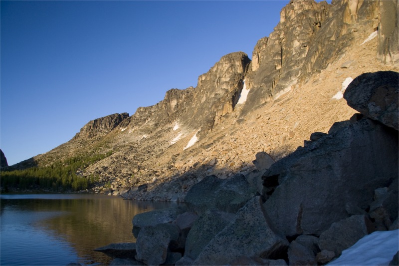
Down into the other side of the saddle we could see Upper Cathedral Lake, back-dropped by huge cliffs and a small shallow melt-pool / pond to its upper right.


After a rest and photo opportunities at the Saddle, we wandered down into the Cathedral area. We were giddy with excitement for how pretty it was and knowing we had almost accomplished another solid day on the trail.
We stopped at the pool to check it out – it was shallow – maybe two feet at best with a muddy bottom. It was also apparently a breeding ground for mozzies – as there was a lot of Lava floating on the surface – which swam down into the pool if the surface was disturbed with a pole.

After sticking our feet in – it didn't feel too cold – so we decided to take a little dip. I leaped in first, followed by Nigel and then Tim. Bill wasn't going to fall for it – he knew all too well that the mozzies love him – and would likely be eaten alive if he got so exposed.
I can't think of anything more invigorating for the body and soul than dipping in a cold mountain lake after a few days of backpacking. Outstanding!
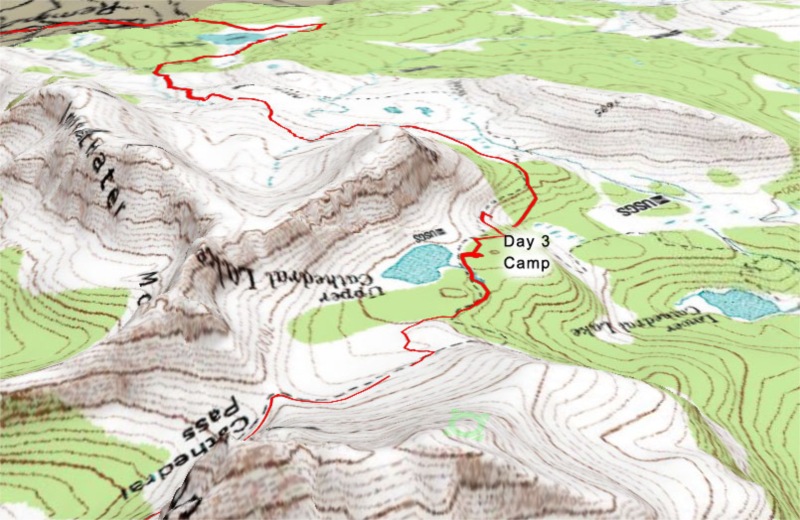
After drying out in the sun – we put out gear back on and head down to the main lake to find camp spots.

The camp sites along the shore of the lake were closed for restoration, so we ended up camping in what appeared to be a horse camp up on a slight hill – with peek-a-boo views of the lake.
We had not passed another sole all day – and were the only people camped at the lake. Hard to imagine on a year were there are little other places to hike (due to lingering snow) and it being well into summer.
We ate a fine dinner – hung our bags, and chilled by the lake watching the sun go down. As the sun dipped, it lit up the cliffs by the lake with warm orange hues and lingering shadows. The trout leaping out of the lake and breaking the silence with their splashes only added to the ambience.


After the light faded over the lake – Tim and Bill found a great spot high up the rocky scree where they could see the rest of the sunset in the other side of the valley down into lower Cathedral Lake and the mountain in the distance.
Total distance for the day: 14.7 miles.

[Oh yeah – Tim gets all the credit for the outstanding photos and the team-player award for lugging in his Canon 20D.]
